


DJI Phantom 4 RTK + D-RTK 2 GNSS Mobile Station Combo dron Quadcopter (CP.TP.00000231.01)
Cijena
7.631,43 €
Dodaj u listu želja
Postavi obavijest o cijeni
Povijest najniže cijene
Podijeli
Prijavi grešku



DJI Phantom 4 RTK + D-RTK 2 GNSS Mobile Station Combo dron Quadcopter (CP.TP.00000231.01)
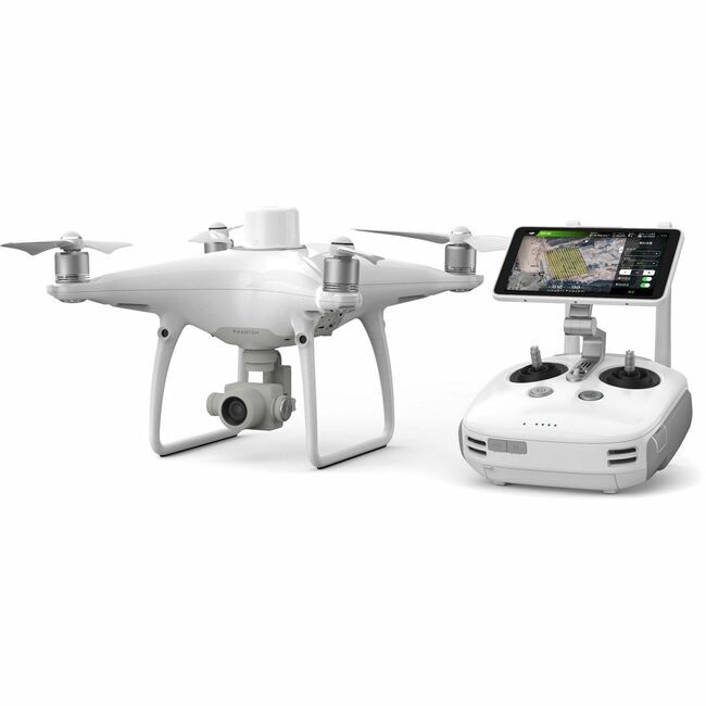
DJI Phantom 4 RTK + D-RTK 2 GNSS Mobile Station Combo dron Quadcopter (CP.TP.00000231.01) ZNAČAJKE: Enterprise-Level Drone Mapping Solution 1cm+1ppm RTK Horizontal Accuracy 1.5cm+1ppm RTK Vertical Accuracy Distortion Calibrated 1" CMOS Sensor TimeSync Alignment for Accurate Metadata Controller with Display & GS RTK App Photogrammetry & Waypoint Flight Modes OcuSync for up to 4.3-Mile Streaming Up to 30 Minutes of Flying Time D-RTK 2 Mobile Station & Tripod Included The Phantom 4 RTK Quadcopter with D-RTK 2 GNSS Mobile Station Combo from DJI is a Phantom 4 quadcopter with additional technology designed to deliver centimeter-level accurate mapping that can be extremely useful for surveying, construction sites, and inspections. Utilizing an RTK receiver on the top of Phantom 4 and a built-in GNSS module, the Phantom 4 RTK can achieve 1cm+1ppm RTK horizontal and 1.5cm+1ppm RTK vertical positioning accuracy. In addition to the RTK receiver and GNSS module, the Phantom 4 RTK can achieve such accuracy thanks to DJI's TimeSync system and the gimbal camera's calibration process. The camera is the same one that's on a standard Phantom 4, but with the Phantom 4 RTK each camera has its radial and tangential lens distortions measured. They are added to the metadata of all captured images, allowing for accurate post-processing that account for the distortions. The Phantom 4 RTK can perform mapping duties in real time, but this bundle also includes a separate D-RTK 2 GNSS Mobile Station and tripod to help compensate for locations where the Phantom 4 experiences poor or no signal. The Mobile Station can access GPS and GLONASS to provide real-time differential data, and can communicate that via OcuSync, 4G, Wi-Fi, or LAN. When mapping, pilots can utilize the Photogrammetry and Waypoint Flight modes in the GS RTK app which give mapping-specific functionality, such as selecting flight paths and directly loading KML area files. Combine it all and you have an enterprise-level mapping solution that can be used right out of the box. DJI Phantom 4 RTK Quadcopter with D-RTK 2 GNSS Mobile Station Combo The Phantom 4 RTK Quadcopter with D-RTK 2 GNSS Mobile Station Combo from DJI is a Phantom 4 quadcopter with additional technology that is designed to deliver centimeter-level accurate mapping that can be extremely useful for surveying, construction sites, and inspections. Utilizing an RTK receiver on the top of Phantom 4, and a built-in GNSS module, the Phantom 4 RTK can achieve 1cm+1ppm RTK horizontal and 1.5cm+1ppm RTK vertical positioning accuracy. In addition to the RTK receiver and GNSS module, the Phantom 4 RTK can achieve such accuracy thanks to DJI's TimeSync system and the gimbal camera's calibration process. The camera is the same one that's on a standard Phantom 4, but with the Phantom 4 RTK, each camera has its radial and tangential lens distortions measured. They are added to the metadata of all captured images, allowing for accurate post-processing that account for the distortions. The Phantom 4 RTK can perform mapping duties in real-time, but this bundle also includes a separate D-RTK 2 GNSS Mobile Station to help compensate for locations where the Phantom 4 experiences poor or no signal. The Mobile Station can access GPS and GLONASS to provide real-time differential data and can communicate that via OcuSync, 4G, Wi-Fi, or LAN. When mapping, pilots can utilize the Photogrammetry and Waypoint Flight modes in the GS RTK app, which give mapping-specific functionality, such as selecting flight paths and directly loading KML area files. Combine it all and you have an enterprise-level mapping solution that can be used right out of the box. Mapping Technology RTK + GNSS for Centimeter Accuracy The RTK receiver and GNSS module work together to provide flight stability along with centimeter-level mapping accuracy on image metadata. With the Phantom 4 RTK, you can achieve 1cm+1ppm RTK horizontal positioning accuracy, 1.5cm+1ppm RTK vertical positioning accuracy, and 5cm absolute horizontal accuracy of photogrammetric models (when flying at 100m high, 2.7cm GSD, on a sunny day. The RTK receiver can also be connected to the included D-RTK2 Mobile Station, NTRIP (Network Transport of RTCM via Internet Protocol), or it can store its data to be used in PPK (Post Processed Kinematics) after the flight. TimeSync The TimeSync system is engineered to help ensure the Phantom 4 RTK's ability to achieve centimeter-level accuracy. It continually aligns the flight controller, camera, and RTK module, as well as fixing the positioning data to the center of the CMOS. These optimizations give each photo the most accurate metadata possible. Phantom 4 RTK Controller The included controller with display is specifically designed for industrial users. It's pre-loaded with the GS RTK App, includes a microSD card slot, built-in speaker, and hot-swappable batteries. The controller can also connect to the internet for Network RTK with the...
7.631,43 €

- Raspoloživo, isporuka odmah u trgovini
- Raspoloživo, isporuka do 2 dana po uplati
- U dolasku, po narudžbi
- Raspoloživost potrebno provjeriti
- Nije raspoloživo
Ocjene i komentari
Posjetitelje koji su gledali ovaj proizvod također su zanimali i proizvodi